
![]() Follow us on Facebook
Follow us on Facebook
![]()
This page is one small part of Good Sites for Kids!
GEOGRAPHY
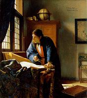 The
Geographer ("De Geograff"),
The
Geographer ("De Geograff"),
by Johannes Vermeer, painted 1668-69.
Click on the painting to learn more about
Vermeer and the 17th century Netherlands.
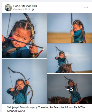
Five-year-old
Mongol girl practicing the tradtional
art of horseback archery. It got them an empire once.
50 States Basic facts on all 50 states of the USA.
![]() 50 States in 10 Minutes
Can you type in the correctly spelled names of all 50 US states in 10 minutes?
Type them in any order, can even be all lowercase, but must
be correctly spelled. "Helpful" countdown timer tells you
how much time is left, adds stress.
50 States in 10 Minutes
Can you type in the correctly spelled names of all 50 US states in 10 minutes?
Type them in any order, can even be all lowercase, but must
be correctly spelled. "Helpful" countdown timer tells you
how much time is left, adds stress.
A Year of Reading the World- The list This is the list of 196 books, one from every country in the world, that Londoner Ann Morgan read in 365 days. An article from the BBC, " Reading the world in 196 books " tells the story of her quest to even find a book from every country. An article from The Atlantic discusses her favorites among the 196 books. Amy Poehler's Smart Girls on FB endorsed this. We endorse it because we feel learning about the people in the other 195 countries is essential to a young person's education.
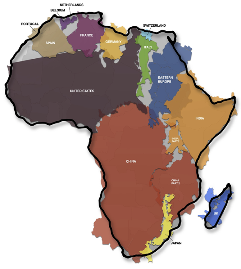
Africa is much larger than it is shown on most maps! Honest!
Atlapedia Like an online almanac, with country info and stats, political and regional maps, and downloadable maps.
A brief history of time zones is a brief history of time zones via interactive globe. This BBC site shows every time zone all around the world. GMT is explained, International Date Line, times zones in different countries, daylight saving time, and more. Kids can slide the horizontal scrollbar to move to other time zones and read more articles.
Ancient
Silk Road – First Global Supply Chain
This is a commercial site that specializes in teaching
principles of business and logistics through case studies.
Accurate and wonderful descriptions and maps explain
the distances, trade goods, and the cities along the way.
Students do NOT have to subscribe and do the case study
(unless they want to and have the funds and the knowledge).
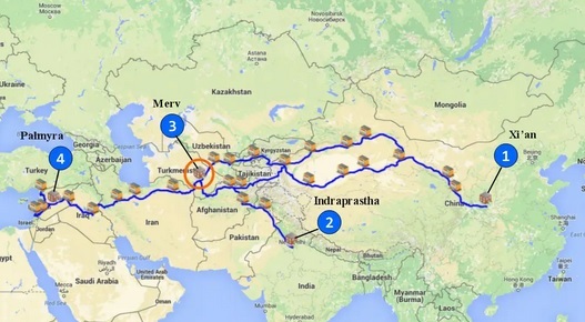
"The Ancient Silk Road was approximately 4,000 miles (6,440
km)
from its start in China to its end on the shore of the eastern
Mediterranean. This compares with 2,440 miles ( 3930 km) between
New York and Los Angeles, and 1,760 miles (2,830 km) between Paris
and Moscow."
Covers the oasis cities, the camels that carried the goods, the
various merchandise they transported:
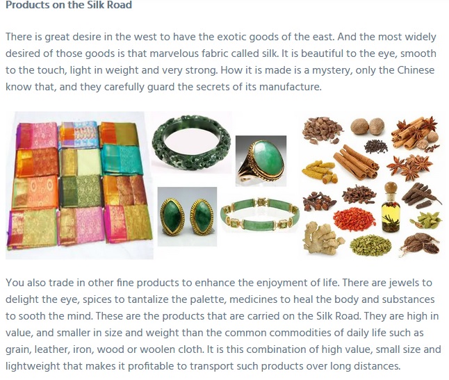
"You are head of the largest merchant trading house on the Silk Road. It
is
the year 210 AD, and the long prosperity of the Pax Romana has created
strong demand in the Roman Empire for the luxury products you import from
China and India. Chief among those products is silk. Everybody who is
anybody wants their clothes made of silk.
Along the length of the Silk Road stretching from the borders
of the
Roman Empire in the west to the Middle Kingdom (China) in the east,
there are many cities and many merchants, yet all know your company and
your name : you are the Trading House of Barmakid, in the city of Merv."
'Black Marble' satellite images of Earth unveiled - in pictures "Scientists have unveiled a new image of Earth at night. A global composite image, dubbed Black Marble, was constructed using cloud-free night images from a new Nasa and National Oceanic and Atmospheric Administration satellite. It shows the glow of natural and human-built phenomena across the planet in greater detail than ever before." Ten images show pretty much all of Earth at night. Geography classes could work on identifying continents, countries, cities and towns, lakes, oceans, highways, oil fields, fishing fleets, etc. Credit: This slideshow is posted in the Science section of theguardian.
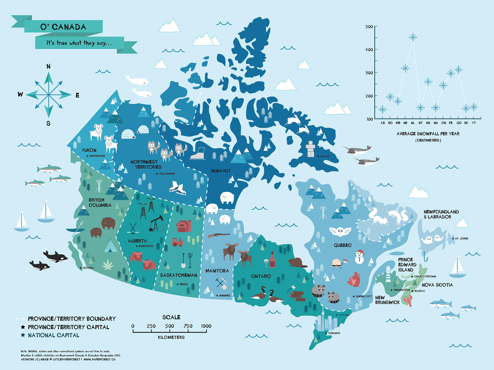
Map
of Canada by littlepaperforest on deviantart.
Charming, whimsical, and BIG (1600x1200) map.
All the provinces and capitals are shown, also what
each province is known for. This is all over Pinterest,
too, but the original's on deviantart.
CIA World Factbook Excellent information source for any country in the world. Well laid out site. It's now a secure site. Well, it is the CIA.

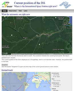
International Space Station - Current position of the ISS "Where is the International Space Station right now?" You can find that out with this site! It always shows "What the astronauts see right now.", which is a straight down view onto a Google Earth surface. "Ground track" shows the ISS' position on a map of the world. Both displays are always on, and are updated by the second. UTC time, latitude and longitude, speed, and altitude are all shown. Choose between miles and kilometers. What a wonderful data source for mathematics story/word problems, geography projects, and astronomy.
Chinese Zodiac Why is 2024 the Year of the Earth Dragon? How many animals are there, how many colors and elements? What is there a 60 year cycle and a 12 year cycle? Find out all about it this series of sites. Each animal in the zodiac gets its own long page of facts overload! At the bottom of each page is a list of all the animals in the zodiac. Each has its Chinese character and how to say it in Chinese. Quite a resource. https://www.travelchinaguide.com/intro/social_customs/zodiac/
Earth's Seasons from Enchanted Learning. Find out about the Equinox, the Solstice, and the seasons of the year at this fine offering.
![]() Educational
games from Digipuzzle.net.
"On this page you can find the overview of the educational games from Digipuzzle.net.
All games can be played full screen on a PC, a tablet (Android Tablets, iPad,
etc) or mobile phone (Android, iOS)." Here's a diverse group of kids' games,
from numeracy to multiplication, with some early language arts, some geography,
time, hieroglyphics, and some money math. Here they are by subject with the
number of games in parentheses:
Educational
games from Digipuzzle.net.
"On this page you can find the overview of the educational games from Digipuzzle.net.
All games can be played full screen on a PC, a tablet (Android Tablets, iPad,
etc) or mobile phone (Android, iOS)." Here's a diverse group of kids' games,
from numeracy to multiplication, with some early language arts, some geography,
time, hieroglyphics, and some money math. Here they are by subject with the
number of games in parentheses:
A big Thank You to Marcel van de Wouw. These are nice!
![]() Famous Canadians
"The infographic is a virtual Canadian Hall of Fame. It showcases influential
Canadians who have contributed to scientific and social development, economic
security and prosperity, and the creative arts. The infographic was designed
to show visitors that Canada is home to great people who were visionaries and
history-makers." This very informative page is from CanadaFaq,
a site devoted to "Everything You Need to Know About Canada"; geography,
history, people, finance, education, economy, immigrating, jobs, etc. Kudos
to Vera Johnes at CanadaFaq, for the
email telling us about this fine web site.
Famous Canadians
"The infographic is a virtual Canadian Hall of Fame. It showcases influential
Canadians who have contributed to scientific and social development, economic
security and prosperity, and the creative arts. The infographic was designed
to show visitors that Canada is home to great people who were visionaries and
history-makers." This very informative page is from CanadaFaq,
a site devoted to "Everything You Need to Know About Canada"; geography,
history, people, finance, education, economy, immigrating, jobs, etc. Kudos
to Vera Johnes at CanadaFaq, for the
email telling us about this fine web site.
Flags of the World is the world's oldest and largest site about flags. "Here you can read more than 49,000 pages about flags and view more than 91,000 images of flags of countries, organizations, states, territories, districts and cities, both past and present." There are several ways to look up flags, too.
GIS Resources "Resource for GIS Welcome to the World of Global Information Systems" Lots of valuable links to maps sites, GIS lesson plans & education sites, geography links, and much more! Along with its sister GPS site, this is part of an Illinois-based ed initiative.
GPS Resources "Welcome to the World of Global Positioning Systems. The following links will hopefully give the participants a resource to obtain information about GPS, sources to companies related to GPS, projects that are using GPS, and educational sites that have a wealth of information." A wealth of information about, and links to, GPS lesson plans and activities, Geocaching activities, the Travel Bug project, more. Along with its sister GIS site, this is part of an Illinois-based ed initiative.
Geography Maps : Atlas of Europe and World Atlas Two separate sections highlight all the countries, rivers, and mountain ranges of Europe and of the entire world. Great geography resource.
Geography Dictionary & Glossary - The ABC of Geography "Welcome to possibly the most comprehensive geographic related dictionary on the internet for students... Over 1400 terms defined. This dictionary is primarily aimed at supporting secondary/senior/high school and early tertiary students who are studying Geography or related subjects such as Earth Sciences." Everything A to Z, from Abiotic to Zonal Soil. This excellent site from Hong Kong will become your fast reference for geographical terms. We want to thank Danny Harrington (BA Hons. Oxon), for this great addition to these pages.
 Geography
from Spacefrom the Smithsonian. "The Geography from Space contest is
held every year during National Geography Awareness Week (in November). Contestants
are challenged to identify geographic locations on the Earth based on a satellite
or aerial image and a brief clue." The quizzes on this page are from the
previous 10 years, at this point (9/2013). They are great, challenging geography
questions.
Geography
from Spacefrom the Smithsonian. "The Geography from Space contest is
held every year during National Geography Awareness Week (in November). Contestants
are challenged to identify geographic locations on the Earth based on a satellite
or aerial image and a brief clue." The quizzes on this page are from the
previous 10 years, at this point (9/2013). They are great, challenging geography
questions.
![]()
Geography Quiz Online point and click interactive quizzes on US states, Canada, China, Europe, Australia, Asia, Africa, Middle East, Central and South America, Caribbean, Oceania, and Continents and Oceans. (Try saying that fast.) We used these with teenagers, and the quizzes are very good.
Geography
Quiz from Learning
Planet.
Fast interactive USA political geography for 4th grade and up.
Geography Quizzes from JetPunk. Big list of good online quizzes.
Here are a couple of related online
games
from Seterra:
South America: Countries - Map Quiz Game
North and Central America: Countries
Geoguessr "Embark on a journey that takes you all over the world. From the most desolate roads in Australia to the busy, bustling streets of New York City." May be too hard for middle schoolers unless they do it in groups. Teachers could walk younger students through the game by asking questions of the class and giving hints. It's a game to see if you can figure where you are, using Google Street View. All you know at the start is that you are somewhere on Earth. If that's too much area for you, there are maps of cities (New York City, London, Paris, etc.) and of countries (Canada, Australia, UK, Netherlands, etc.) and the European Union! Be a detective and a geographer. It's fun to use clues such as traffic signs, language, architecture, climate, trees, crops, and anything else you can find. ("Hmm. Olive trees and palm trees. That sign looks like it's in Spanish.") You could look up names of towns. ("I wonder what country Poznan is in?") Talk about honing skills! Try it out!
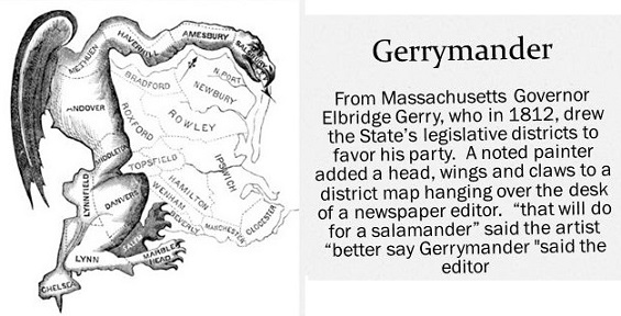
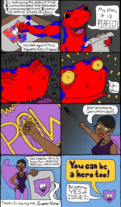
What Is Gerrymandering? A short video explains what's wrong with this ugly political practice. Watching it gives learners the needed background to appreciate the importance of fighting gerrymandering with geometry!
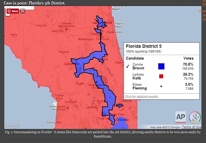
Meet
the Math Professor Who’s Fighting Gerrymandering With Geometry
This link's from A Mighty Girl's Facebook site. The
original article
from The Chronicle of Higher Education explains it in a more academic way.
Basically, Professor Moon Duchin of Tufts University, "has helped create
a
program to train mathematicians to serve as expert witnesses in court
cases over redrawn electoral districts." Since courts all the way up to
the US Supreme Court have problems understanding gerrymandering,
this is a good plan to overcome this evil practice.
Read one or both articles, and learn.
The History Cat "The mission of the History Cat is simple: change the way students learn about history. We've set out to answer the age-old question that every teacher asks: "How can I motivate teens to read a textbook?" Now, we're not talking about skim reading or zombie reading, but actual reading. Like eyes following words, minds creating images, reading. After all, if history doesn't tell a good story, what's the point?"
This site constantly adds new things to read and do. American and World History, World Geography, Global Religions, Choose Your Own Adventure, links, more. Oodles of subcategories in each! We ran on the Underground Railroad, read about Archduke Ferdinand's assassination, checked out the Silk Road, learned about African geography ("Place is huge!"). This is middle school through high school level, maybe first year college - anyway, excellent site! Shout out to "veteran social studies teacher" Ken Uhde, of Groves High School, Birmingham, Michigan, its creator!
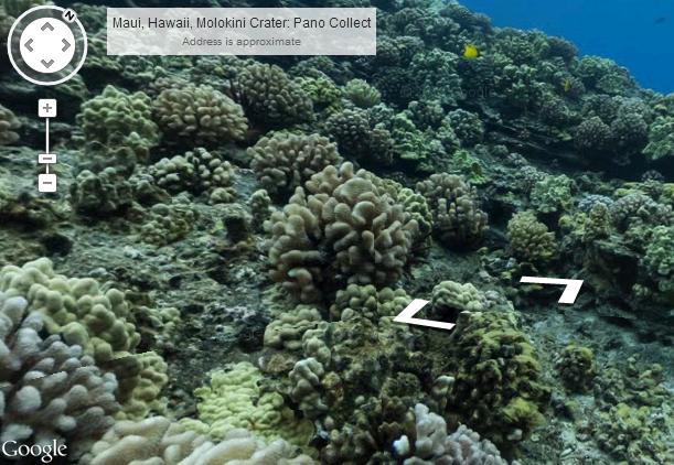 Google
Streets in the Deep The Instructify
site wrote: "The good people at Google Street View have recently partnered
with The Catlin Seaview Survey
to provide underwater street views (italics
ours) of several breathtaking reefs around the world. You can take your students
on a fieldtrip to swim with sea turtles and manta rays without having to be
scuba-certified. From identifying the variety of aquatic life forms depicted
in and around the reefs to writing short stories set in the reefs; the possibilities
for classroom use are as wide as the ocean and as deep as the sea. You can explore
the complete collection here."
Google
Streets in the Deep The Instructify
site wrote: "The good people at Google Street View have recently partnered
with The Catlin Seaview Survey
to provide underwater street views (italics
ours) of several breathtaking reefs around the world. You can take your students
on a fieldtrip to swim with sea turtles and manta rays without having to be
scuba-certified. From identifying the variety of aquatic life forms depicted
in and around the reefs to writing short stories set in the reefs; the possibilities
for classroom use are as wide as the ocean and as deep as the sea. You can explore
the complete collection here."
Gall-Peters vs Mercator Two different projections of the world map.
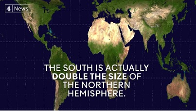
One is much more accurate comparing sizes of islands and continents; the other is traditional, comfortable, and exaggerates the size of the northern (or "white") countries. Watch the video, then research this for your own edification.
Grand Canyon Street View from Google. Explore the Grand Canyon, Colorado River, Phantom Ranch, and Meteor Crater! This wonderful grouping is FREE and you can look at these landmarks from anywhere! There's even music if you want it.
Hang Son Doong
from Ryan Deboodt (6:19 video) "Take an otherworldly journey through Hang
Son Doong, the world's largest cave, by both ground and air. Filmed near the
entrance and the first and second dolines (skylights) which are 2.5 and 3.5
km inside the cave respectively." "The Son Doong Cave in Vietnam is
the biggest cave in the world. It's over 5.5 miles long, has a jungle and river,
and could fit a 40-story skyscraper within its walls."
The Son Doong Cave.org official site
has huge amounts of photos and other graphics, and lots of data. As if that
weren't enough, there's a Pinterest
page.
WE ARE A HORSE NATION
“This Film will tell the world our stories, and show the world our visuals,
from our own perspectives... as the Oceti Sakowin. To present a quality Documentary
Film that will tell the story of why we (Oceti Sakowin) are a “Sunka Wakan
Oyate” (Horse Nation). This film will present that story through the voices
of the Oceti Sakowin (Lakota, Dakota & Nakota). This project will be a working
example of the philosophy of the Oceti Sakowin, and as “relatives”
we will bring together Traditional & Contemporary Lakota/Dakota/Nakota songs,
stories, teachings, experiences, knowledge, thoughts & beliefs, to be compiled
for a one-of-a-kind film resource; to be utilized by the intended audience of
the future generations of the Oceti Sakowin." This is a seven minute preview.
Kids Web Japan is a great site about Japan for kids. Everything kids would want to know is here, including anime and manga. Also history, culture, folk tales, interactive things to make and do, etc.
Language Guide Want to learn alphabets and vocabulary words from other languages? "LanguageGuide.org offers free sound integrated resources for learning languages." The site features pictures of various things with written and spoken names in several languages. Words are pronounced by volunteer native speakers. Current languages are English, Spanish, French, German, Italian, Brazilian Portuguese, Russian, Hebrew, Arabic, Mandarin Chinese, and Japanese. Sponsored by Language Guide, a registered non-profit organization, the site is free to use but they do ask for donations. Uses QuickTime.
Lat-Long.com "Search More Than 2 million U.S. Locations in an Instant! Search More than 2 Million Places: Parks, cemeteries, bridges and post offices. Find these and more on Lat-Long.com." This site is a list of all 50 US states. You can click on a state and check out its features by category (did you know South Dakota has 91 canals?) or you can search by item and a state pulldown menu from the main page (example: glaciers in Alaska.) Google Maps display each item. Latitudes and longitudes are given in tradish degrees, minutes, and seconds; also in decimal degrees.
Maps4Kids "Data is available on every State in the US, as well as for every Country in the world ! Maps4Kids.com is a great resource for fast facts about places in our world. The Top 10 page shows you the highest, longest, most populous."
 with an interactive map.") Medieval
Map "This website illustrates the historical changes that occurred
in the Medieval Era (400 - 1500) with an interactive map." Understatement!
Move back and forth through time in 10 to 50 year intervals. Click on one button
to show cities, another to show decisive battles. Click the ? button to see
a modern map. For battles, there is a brief synopsis in a popup window, with
the option to go to Wikipedia. Clicking on a city icon sends you directly to
Wikipedia. The map shows all the contemporary peoples and states for the period
you choose. Clicking on any label (example: "Balts") brings up a three-section
pie graph. One section - the "W", sends you to Wikipedia. Clicking
the folder" icon opens up a book or article, if there is one (in this case
an e-book called "The Balts", by Marija Gimbutas). Clicking on the
"film" icon will open a video, if there is one. The site is constantly
being improved. It's quite a trip through time for middle school and older.
Visual learners may finally grasp the idea of huge groups of peoples moving
across Europe. See empires and kingdoms rise and disappear. Wonder at names
like the Umayyads, the White Sheep Turks, the Principality of Polotsk, Navarre,
Swabia, Trebizond, and all the rest.
Medieval
Map "This website illustrates the historical changes that occurred
in the Medieval Era (400 - 1500) with an interactive map." Understatement!
Move back and forth through time in 10 to 50 year intervals. Click on one button
to show cities, another to show decisive battles. Click the ? button to see
a modern map. For battles, there is a brief synopsis in a popup window, with
the option to go to Wikipedia. Clicking on a city icon sends you directly to
Wikipedia. The map shows all the contemporary peoples and states for the period
you choose. Clicking on any label (example: "Balts") brings up a three-section
pie graph. One section - the "W", sends you to Wikipedia. Clicking
the folder" icon opens up a book or article, if there is one (in this case
an e-book called "The Balts", by Marija Gimbutas). Clicking on the
"film" icon will open a video, if there is one. The site is constantly
being improved. It's quite a trip through time for middle school and older.
Visual learners may finally grasp the idea of huge groups of peoples moving
across Europe. See empires and kingdoms rise and disappear. Wonder at names
like the Umayyads, the White Sheep Turks, the Principality of Polotsk, Navarre,
Swabia, Trebizond, and all the rest.
Mount Everest Gigapan These are some amazing jaw dropping zoom WAY in wide angle pan of Mount Everest and the area around it. The views are absolutely astounding. You can zoom in on people! It's mountain and glacier time! Anyway, just go there and zoom around.
Multicultural Education through Miniatures from the College of Education, University of South Florida. "Multicultural Education through Miniatures includes photos, maps, stories, and games of handmade dolls and puppets from all over the world. This website can increase global awareness for children and adults. Explore by clicking Select a Photo, See Entire List, or Click a Map. Cultural games are also available at Go to Activity. Students and teachers can use the pictures, stories, and games for educational purposes." This site will increase geographical awareness. It is at an upper elementary reading level, also the dolls are amazing!
My Wonderful World "Geography is more than places on a map. It's global connections and incredible creatures. It's people and cultures, economics and politics. And it's essential to understanding our interconnected world." Thanks, Tessia.
National Geographic Kids "Features different people, animals, and places each month with facts, games, activities, and related links." Well, hey, it's National Geographic. Very educational, and the games are fun, too.
National Geographic Map Machine Zoom in on locations worldwide.
National Geographic Xpeditions Atlas Maps made for printing and copying.
Native Words Native Warriors. The story of the Code Talkers in World Wars One and Two, from the Smithsonian Institution's National Museum of the American Indian. Well done site tells the story of these good, brave men, as told by the Code Talkers themselves. Plenty of photos and explanations.
Netstate "Learn About the 50 States! Armadillos to Yellowhammers!" (What about Zap, North Dakota?) Kinda like 50States but different. Besides having a Visit the States window listing all 50 states, this site has a menu of categories on the left side of the main screen that offers tons of information about each state.
 Oglala
Lakota College A tribally controlled institution serving the educational
needs of the Lakota Oyate, focused on the Pine Ridge reservation. Use their
History and Culture menu to access their excellent Oglala
culture site, Lakota Archives,
their large collection of Lakota language audio files, and much more.
Oglala
Lakota College A tribally controlled institution serving the educational
needs of the Lakota Oyate, focused on the Pine Ridge reservation. Use their
History and Culture menu to access their excellent Oglala
culture site, Lakota Archives,
their large collection of Lakota language audio files, and much more.
Ology from the American Museum of Natural History. We love this site! It covers "Ologies" such as Archaeology, Astronomy, Biodiversity, Earth, Einstein, Genetics, Marine Biology, Paleontology, and Water. The bottom half of the page has links to around 20 activities, experiments, and interviews. Then there's the Highlights section, Ask a Scientist, an Advanced section, and At the Museum. Click on the blue buttons in the At the Museum box. Only part of this great site is shown at a time. Be sure to use the Search box and enter a term like "horse" to find a ton of other information.
![]()
Othere's
Voyage to the White Sea, as told to Alfred the Great
In the late Ninth Century a Norseman arrived at King Alfred of Wessex’s
court.
The stories he told the king were recorded for posterity by a court scribe.
This is a retelling of that Ninth Century document recording the exploits of
a Ninth Century resident of Norway’s northernmost province.
The video descibes the voyage around the top of Norway and down into the
White Sea. It decribes the peoples Othere encounters, who were
close relatives of Finns and Saami
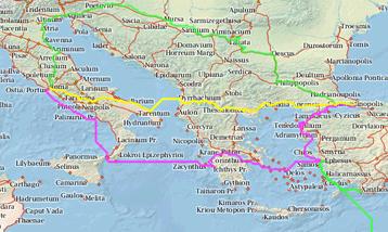 ORBIS
The Stanford Geospatial Network Model of the Roman World. This is not
your normal map! "ORBIS allows us to express Roman communication costs
in terms of both time and expense. By simulating movement along the principal
routes of the Roman road network, the main navigable rivers, and hundreds of
sea routes in the Mediterranean, Black Sea and coastal Atlantic, this interactive
model reconstructs the duration and financial cost of travel in antiquity."
Short version: Travel the rivers, roads, and seas of the Empire! Find out how
long it took and how much it cost. Lots of ways to get from point A to point
X, depends on who you are and how much money and time you have. There's a menu
bar along the top. Click Using ORBIS
to watch a tutorial (it's good, we recommend it). Click the Adobe Acrobat Reader
symbol at the the top right corner of the page to get the tutorial, lesson ideas,
and explanations in .pdf form. Clever teachers could adapt this for any level
from upper elementary up to college-level. It's that good. Different in purpose
from the excellent Digital
Map of the Roman Empire but both are quite detailed.
ORBIS
The Stanford Geospatial Network Model of the Roman World. This is not
your normal map! "ORBIS allows us to express Roman communication costs
in terms of both time and expense. By simulating movement along the principal
routes of the Roman road network, the main navigable rivers, and hundreds of
sea routes in the Mediterranean, Black Sea and coastal Atlantic, this interactive
model reconstructs the duration and financial cost of travel in antiquity."
Short version: Travel the rivers, roads, and seas of the Empire! Find out how
long it took and how much it cost. Lots of ways to get from point A to point
X, depends on who you are and how much money and time you have. There's a menu
bar along the top. Click Using ORBIS
to watch a tutorial (it's good, we recommend it). Click the Adobe Acrobat Reader
symbol at the the top right corner of the page to get the tutorial, lesson ideas,
and explanations in .pdf form. Clever teachers could adapt this for any level
from upper elementary up to college-level. It's that good. Different in purpose
from the excellent Digital
Map of the Roman Empire but both are quite detailed.
 Oregon Trail for Elementary
Schools This is arguably the best Oregon Trail site. Plenty of information
and links. Comprehensive overview of life on the Trail. William has a broken
arm. You have died of desentery.
Oregon Trail for Elementary
Schools This is arguably the best Oregon Trail site. Plenty of information
and links. Comprehensive overview of life on the Trail. William has a broken
arm. You have died of desentery.
Oregon
Trail - End of the Oregon Trail Anything you would ever want to know about
the Oregon Trail, and much more. This huge site could and should be the source
of many K-12 lesson plans. You should have bought
more baking soda saleratus. You do not have an extra wagon
wheel, so you must trade for one.
Oregon Trail Links A large list of links to other OT sites. If you continue hunting in this area, game will become scarce.
Panwapa - Where Kids Shape the World. "Panwapa is an imaginary floating island with characters, stories, and global explorations for kids ages 5-9. Panwapa characters introduce kids to concepts of learning about and accepting other cultures. Educators who use Panwapa can create a group on Curriki to extend and comment on the curricular questions which go along with the Panwapa videos, playalong games, and lessons." This site is great! Talking animated characters engage kids and help them choose from a variety of wonderful things to do. You have to check it out, it is great! From the Sesame Street people.
Pirates for Kids from Mr. Nussbaum "features Pirate Biographies, Stories, Games, and Activites for Kids." Nine sections, for kids grades K - 6. Pirates of the Carribean, Barbary Pirates, Famous Pirates, Pirate Flags, Pirate Vocabulary, Interactive Pirates, Explorers, and two math games: Place Value Pirates, and Decimals of the Caribbean.
Quizzes.cc - Online Quizzes, Tests, Trivia, Worksheets, and Free Games "... provides math quizzes for teachers and students. You can create a quiz and select the range of numbers you'd like to use. Students can grade the quiz online and generate new problems for more practice." Quizzes for all four elementary operations, plus times table quizzes and a nice metric conversion chart. There are also children's literature, science, and geography quizzes. Secondary students can practice metric conversions, some middle school science, and world geography. Thanks to John@Quizzes.cc for the email!
Reading
a Map A kids' site from WebRangers,
National Park Service (NPS), US Department
of the Interior.
This interactive video walks kids through map reading.
It introduces
topography - depictions of hill, streams, trails,
etc. , what hilltops, slopes,
and flat land look like on a "topo"
map. Goes over parts of a map;
legend, scale, and direction
indicator or compass rose. Following trails on
a map is covered.
This elementary activity does not cover, saddles, canyons,
or
passes; but it does lay a foundation for further learning.
There are also
links to more about maps,
a Teachers'
Resource Guide, and links to many
other WebRangers activities.
Sami People: Facts And History
The Sami (Sámi) people, who live in the
far north of Europe, have never had a
sovereign state of their own, and today,
they live in four countries: Norway,
Sweden, Finland, and Russia.
Approximately 80,000 Sami people live
in these four countries; however, around
half live in almost all parts of Norway.
Currently, there are Sami political, cultural,
and youth organizations in all four countries
and a Sami Parliament in each of the three
Scandinavian ones. Lots of pictures and facts.
SCORE History/Social Science "Over 5000 websites aligned to California's History/Social Science Curriculum." Explore Resources and Lessons by Standard, Grade Level Topic, or Keyword. Explore Children's Literature lesson plans/thematic units by Grades K-5 and 6-8. Help for Teachers includes - help! Also useful links such as the California Learning Resource Network ("A Guide to Standards-Aligned Electronic Learning Resources and Assessments for Teachers, Administrators, and Parents"), a whole section on Technology and Social Science - with its own lesson plans and ideas, lots more!
![]() Seterra - Learn Geography."Seterra
is a challenging educational geography program with 70 different exercises.
Learn about states, provinces, countries, capitals, flags and cities in Africa,
Europe, South America, North America, Asia and Australia, using outline map
exercises!" Quick, what's the capital of Slovenia? Of Texas? Where is Uppland?
Find Burkina Faso! Find West Virginia! Click on Malta! This is wonderful freeware
that really works with kids ages 9 and up - we've used it! Great for high school
and college geography, too. From the talented lady in Sweden who brought you
Sebran! New
and improved! Seterra can now be played online,
and micro-countries are included! Used and loved
by geography teachers, it's one of our faves!
Seterra - Learn Geography."Seterra
is a challenging educational geography program with 70 different exercises.
Learn about states, provinces, countries, capitals, flags and cities in Africa,
Europe, South America, North America, Asia and Australia, using outline map
exercises!" Quick, what's the capital of Slovenia? Of Texas? Where is Uppland?
Find Burkina Faso! Find West Virginia! Click on Malta! This is wonderful freeware
that really works with kids ages 9 and up - we've used it! Great for high school
and college geography, too. From the talented lady in Sweden who brought you
Sebran! New
and improved! Seterra can now be played online,
and micro-countries are included! Used and loved
by geography teachers, it's one of our faves!
SquinchPix Image Resource - "An Archive of European Imagery" Utterly astounding. Many thousands of artifacts, sculptures, paintings, castles, churches, temples, dishes, jars, ancient helmets, Minoan buildings, Pompeii, etc etc etc. All labelled by date made/built and location.
State and County Quick Facts from the US Census Bureau. Tons of facts about US states and their counties.
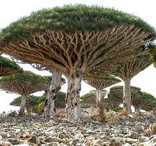 Strange
plants of Socotra Island "It is like being on a different planet...
These pictures and information are excellent viewing and reading. Socotra Island:
You have to see it to believe it. This island simply blows away any notion about
what is considered 'normal' for a landscape on Earth." Lots of photos of
these unearthly, yet strangely beautiful plants! Also photos of people, buildings,
beaches, some rare birds, more. Good explanations for it all. Go find Socotra
on a map, people!
Strange
plants of Socotra Island "It is like being on a different planet...
These pictures and information are excellent viewing and reading. Socotra Island:
You have to see it to believe it. This island simply blows away any notion about
what is considered 'normal' for a landscape on Earth." Lots of photos of
these unearthly, yet strangely beautiful plants! Also photos of people, buildings,
beaches, some rare birds, more. Good explanations for it all. Go find Socotra
on a map, people!
![]()
 TimeMaps
specialise in map-based history timelines.
TimeMaps
specialise in map-based history timelines.
TimeMaps' FREE interactive World History
Atlas is the most comprehensive history atlas on the internet. Inside you
will find over 1,500 maps, well-written historical overviews, depth-articles,
images and much more.
Maps and timelines (timemaps) of every civilization, nation and empire. See
the geographical context, chronology, connections and big pictures of history.
FREE!" Fabulous interactive maps that branch
off fractally, let students explore everything about the history of any part
of the world from 3500 BC (5500 BP) to the present day. A short video
shows some examples. The Atlas
shows relationships between peoples and civilizations using graphics and text.
It's full of information. There are also very good and inexpensive iPad, iTunes,
and Chrome apps for sale, from $1 to $3 that we saw, and at least one (The Black
Death) for £1.99. Are the apps worth it! In a word, yes! Our historian
was nearly drooling. They also have available various teaching resources and
materials.
Popular Topics Click & grab the big orange button, then slide the
big orange button to see 13 interactive history timelines for different parts
of the world.
This site is everything it claims to be! Enough! Go see it for yourself!
What Time Is It Around The World Right Now?"This Flash Map of World Time displays current local time in any place around the world right now. World Time Clock & Map is an indispensable utility for everyone who deals with people abroad or anybody who is keen on knowing what time it is further than locally. This advanced Flash application is very helpful for travelers who need to know time difference around the world and want to be aware of world time zone they are traveling to, as well as for businesses which are located in different time zones and want to know current local time of their partners and customers." Also explains Coordinated Universal Time (UTC) and Greenwich Mean Time (GMT), Time Zones, Daylight Saving Time (DST), and Space Time. At the bottom of the page, there are links to Time Maps for Europe, Australia, The U.S., and Canada.
What's my latitude and longitude? Go to this site and it will show you your latitude and longitude, based on your IP address. This could be useful as an introduction/attention step for a lesson on lat & long. Credit to David Stoline and reddit
World Atlas Huge site of geography facts, maps of everywhere! You should check it out. If it has to do with geography, it's in here!
World atlas dot com Huge list of trivia about the world, continents, countries, languages, money, oceans... even gives the weight of continents (how can they tell?)
World Geography Games "Welcome! Can you point out Sudan on the map? How about the Strait of Hormuz? This website will bring you many entertaining and stimulating map games to improve your geographical knowledge. The quizzes include questions about countries, regions, bodies of water, mountains, deserts, metropolitan areas and other topics that will test and challenge your brain. For everyone who wants to explore and learn about the world, you've come to the right place!" Twenty-two very colorful, very accurate, interactive modules. These are all either "click on" _____ or "drag the correct label to" _____ exercises, perfect to learn geographic facts. Modules are forgiving and will help students learn. Available in English, Dutch, German, French, and Spanish. PS: There's a similar game of Europe-only facts, too :Geography Games Europe. GSFK wants to thank Sonja Snoek and her company, EastDock Media in Amsterdam, Netherlands.
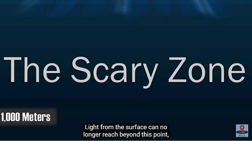
You Really Can’t Imagine How Deep The Ocean Is This page makes a good effort to instill a sense of how deep the ocean is. The ocean is seriously deep! The AVERAGE depth of the ocean is 4,267 meters. The deepest part we know of so far is almost 11,000 meters (11 km). To see only the video portion, click here The Ocean is Way Deeper Than You Think. It's good, even though the narrator is forced to talk fast to keep up with this 6:52 video! To see a much shorter (1:24) CGI video of a sperm whale fighting a colossal giant squid, click here to watch COLOSSAL SQUID Vs. SPERM WHALE
![]() to top of page
to top of page ![]()
![]() to Good Sites
to Good Sites![]()
![]() to Social Studies
to Social Studies
Powered
by ![]() The World's #1 Web Host
The World's #1 Web Host
![]()